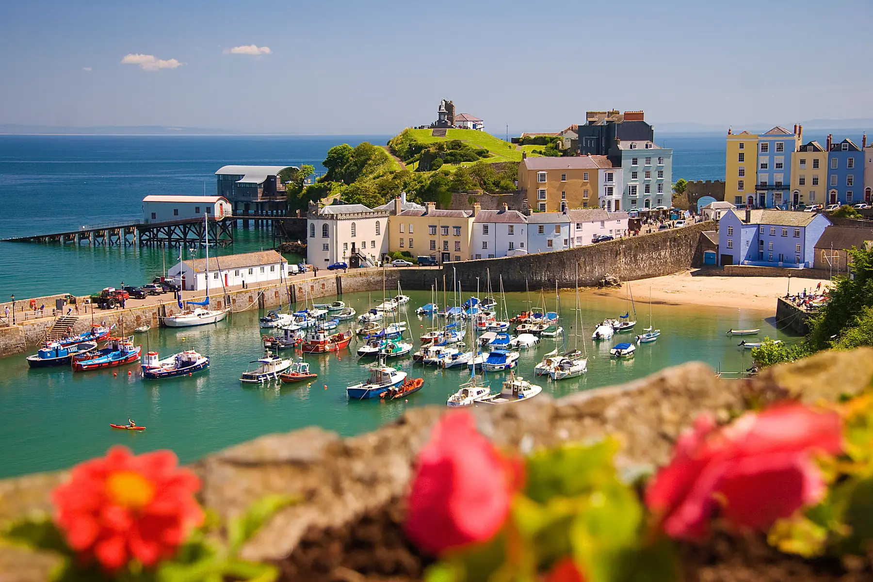
Tenby is a walled medieval town on a headland with beaches on three sides of it, and the Pembrokeshire Coast Path runs straight through the middle. That gives you two quite different sorts of walking: an hour round a town that has changed very little since the Victorians rediscovered it, and days on some of the best cliff walking in Britain in either direction.
The coast north towards Saundersfoot and Amroth is gentler and wooded; the coast south towards Lydstep and Manorbier is higher, wilder and more dramatic.
Distances are from the harbour.
Tenby’s town walls were begun in the 1090s to defend the Norman settlement from the Welsh and were substantially rebuilt in the thirteenth and fifteenth centuries. A long stretch survives, including the Five Arches — the barbican gate on South Parade, which is the town’s most photographed structure after the harbour.
Walking the line of the walls and then through the medieval street plan — High Street, Tudor Square, St Julian’s Street, Frog Street and the lanes down to the harbour — takes about an hour. St Mary’s Church is the largest parish church in Wales, and the Tudor Merchant’s House on Quay Hill is a late fifteenth-century merchant’s home kept by the National Trust.
Cars are banned from the historic centre through the summer, which makes all of this considerably more pleasant.
The harbour is the picture: pastel houses stacked above a small tidal basin with boats drying out at low water. Above it, Castle Hill carries the fragments of Tenby Castle on a headland almost separated from the town, along with the Tenby Museum and Art Gallery — one of the oldest independent museums in Wales — the Prince Albert memorial and a view over both beaches.
Twenty minutes, free, and the best short walk in the town.
The tidal island off Castle Beach, crowned by a Victorian fort built in the 1860s against a French invasion that never came. It is reachable on foot at low tide and cut off at high — check the tide table before you cross, because people misjudge it every summer.
Five kilometres along the coast path over Waterwynch and through woodland above the cliffs to Saundersfoot, a village with a harbour and a beach. It is an easy hour and a half each way, and the walk back along the beach at low tide is an alternative.
From Saundersfoot the old coal tramway tunnels carry the path north along the shore to Coppet Hall and Wiseman’s Bridge — three lit tunnels cut for the nineteenth-century coal trade, and a very odd thing to walk through with the sea beside you.
Continue to Amroth, seven kilometres from Tenby, with a long sandy beach and the remains of a submerged forest visible at very low tides. Colby Woodland Garden, National Trust, sits in a wooded valley just inland — sheltered, full of rhododendrons in spring, and a good wet-weather walk.
Amroth is the southern end of the Pembrokeshire Coast Path, all 190 miles of it, which begins on the beach.
South Beach runs for two kilometres to Giltar Point, the headland at the far end, reached across the golf links at Penally. The point gives the best view back at Tenby and across to Caldey Island.
A practical warning: the ground beyond Penally is the Penally military training area and the coast path is closed when firing is taking place. Times are posted; check before setting out.
Continue to Lydstep Haven and the Lydstep Headland, National Trust, with caves in the cliffs below reachable at low tide. Beyond it, Skrinkle Haven and Church Doors are two small coves reached by a steep flight of steps, with a natural rock arch between them. They are among the most photographed beaches in Wales and among the least convenient to reach.
Eight kilometres south-west. A Norman castle above a beach, founded by the de Barry family in the late eleventh century and still substantially intact — Gerald of Wales, the medieval chronicler, was born here and called it the pleasantest spot in Wales. The beach below is sandy with rock pools.
Carew Castle, nine kilometres north-west, sits on a millpond with a restored tidal mill — one of only four in Britain — and a circular walk round the pond that is level and easy.
The Ritec valley behind South Beach and the lanes towards St Florence give quiet inland walking on a coast where almost everyone stays on the cliffs.
Trains run from Tenby along the coast to Saundersfoot, Kilgetty, Narberth and Carmarthen in one direction and to Manorbier, Lamphey, Pembroke and Pembroke Dock in the other — which makes linear coast walks unusually easy here. Manorbier and Saundersfoot both have stations near the path.
Firing ranges. Penally, immediately south of Tenby, closes the coast path when in use.
Tides. St Catherine’s Island, the Lydstep caves and several of the coves are cut off at high water.
Underfoot. The coast path is cliff-top with steep steps into and out of every cove. It is more strenuous than the distances suggest.
Cars are excluded from the town centre in summer, so park on the edge and walk in.
Spring is when the cliffs come into flower — thrift, sea campion and bluebells in the wooded sections towards Saundersfoot — and the coast path is dry and empty before Easter.
Summer fills the beaches and largely leaves the cliffs alone. An hour’s walk in either direction from the town gets you real quiet even in August.
Autumn is the best walking of the year here: warm sea, clear air, the seal pups appearing along the coast, and the paths empty again after the schools go back.
Winter is when Carmarthen Bay puts on its weather. The walled town in a gale, with the sea running into South Beach, is worth the trip — and the coast path is beautiful and entirely deserted.
Grey seals pup on the beaches below the cliffs from late August into the autumn, and Caldey Sound and the coves towards Lydstep are the places to look from above.
Seabirds — guillemots, razorbills, fulmars and kittiwakes — crowd the cliffs from April to July, and the ledges around St Catherine’s Island and Giltar Point hold nesting birds.
Choughs, the red-billed crow, are on this coast.
And Amroth’s submerged forest — the stumps of trees drowned when sea levels rose after the last ice age — appears on the beach at very low tides after winter storms, which is one of the odder things you can see for nothing in Wales.
Worth spelling out, because Tenby is unusually good for it. The Pembroke Dock line runs through the town with stations at Penally, Manorbier, Lamphey, Pembroke and Pembroke Dock to the west, and Saundersfoot, Kilgetty and Narberth to the north-east.
That means several of the best coast path sections can be walked one way with a train back: Tenby to Saundersfoot, Tenby to Penally and Manorbier, or Manorbier to Lydstep and back into Tenby. For a walking holiday it removes the car entirely, which on a coast where the paths are linear is a considerable advantage.
Services are not frequent — check the timetable before committing to a one-way walk — but they are reliable.
The town walls and Castle Hill for an hour; Tenby to Saundersfoot for a half day; Lydstep and Skrinkle Haven for the best cliffs.
Yes, five kilometres along the coast path, about ninety minutes, with a train back.
At low tide, across Castle Beach. It is cut off at high water — check the tide before crossing.
At Amroth, seven kilometres north-east of Tenby, and runs 190 miles to St Dogmaels.
Yes — the Penally range immediately south of Tenby closes it when firing is taking place. Times are posted locally.